Those of you who know me at all know that I don't like to leave the house. If I've got something I need to do, I have to go straight from work, because once I go home, I'm home. Even on the weekends, I say I'm going to get up and go do stuff, but I don't. I sit in front of the TV thinking that I really should get up and go do stuff, but I don't get up and go do stuff.
Then Monday comes and I go back to work thinking next weekend I'm going to get up and go do stuff.
So, what did I do this weekend? I got up and went and did stuff!
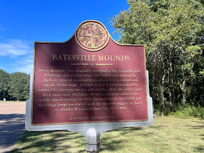
Well, one stuff at least. After 29 years of driving by the signs and thinking I ought to stop, but not stopping, I finally made it up to the Batesville Mounds!
Unfortunately, there isn't really a lot of information about who built the mounds and why, but they are estimated to date to between 100-500 AD. There were originally 5 mounds that they discovered, but only two are intact, and one has been completely destroyed.
There isn't much left of Mound A, just a slight rise in this field. If the sign weren't there, you probably wouldn't even notice it.
Mound C is the most visible, being the tallest and conical.
Mound C:
Next to it, you can see one of the borrow pits, where the people dug up the dirt to build the mounds. It's kind of hard to see in this picture, but in person, it's quite obvious.
All of these mounds are connected by nice, wide paved sidewalks big enough even a wheelchair bound person can enjoy the history and the beautiful scenery. But there are also dirt trails through the woods.
And if you know me at all, you know I had to walk these, too.
These are really nice, too, and take you Mound D, which is almost gone, and to a site where they believe the village once stood. Unfortunately, there aren't any signs, so unless you printed out the map, you won't even know where it was.
I didn't print out the map, by the way. I had to use the map in my Pokémon Go game because I didn't have sense enough to print the real map. Alas, it didn't have the historical sites marked, but I got to spin quite a few Pokestops. Yay! I can send my friends different postcards than the Grenada Airfield Hanger one!
On the other side of the park is a trail -- a paved one -- that takes you to this overlook of the Tallahatchie river.
I could have stood here all day and watched the water flow....But eventually, I had to return to the real world.
Overall, it's a nice little park, and great if you live in Batesville. It's a little too far to drive from here regularly just to walk the trails, but seeing the history and the ancient mounds was way cool. I only wish we knew more about the people who lived there. Who they were. What their lives were like...What happened to them.
One last thing before I go. I finished another hat last night.
I guess I'd better get on that...


No comments:
Post a Comment